New Interactive Map Highlights Local Impact of Corn in Minnesota
A new interactive online map created by the Minnesota Corn Growers Association (MCGA) highlights the local impact made by corn farming throughout Minnesota’s 87 counties.
With a single click, users can access data that breaks down corn production by county along with county-by-county information on corn crop value, stations that sell ethanol-blended fuel, ethanol plants, grain elevators and MCGA members.
The online tool can be accessed at www.mncorn.org/farm-policy/county-stats, or under the “Farm Policy” tab at www.mncorn.org.
“It’s another way to show how corn farming helps grow the local economy,” said MCGA president Ryan Buck, a farmer in Goodhue County. “A strong corn crop means more activity at local businesses and more opportunities to create agriculture-related jobs in the region. Corn farming makes an impact beyond just the farm.”
Minnesota corn farmers harvested 1.386 billion bushels in 2012, valued at over $9.5 billion. There are 350 stations that sell ethanol-blended fuel such as E85, 20 ethanol plants and 621 grain elevators throughout the state.
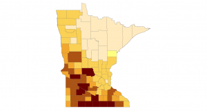
With more than 46.3 million bushels harvested valued over $324 million, Renville County in Western Minnesota led the state in corn production. Redwood County was second with over 40 million bushels valued at more than $280 million.
Hennepin County has 23 stations that sell ethanol-blended fuel, the most of any county in Minnesota. In Greater Minnesota, Stearns County in Central Minnesota leads the way with 14 stations.
Stearns and Kandiyohi County each have 21 grain elevators. Renville County has the most MCGA members with 873.
Corn is grown in 73 of Minnesota’s 87 counties. There are 36 E85 stations and 19 grain elevators in counties where no corn production was reported for 2012.